The Northern Coast of Honduras is developing quickly. With increased demand for land to expand agro-industrial crops such as oil palm, sugar cane and bananas, the need to create effective mechanisms and strengthen key institutions to preserve protected areas and invaluable natural, cultural and strategic resources is more relevant than ever.
Five years ago, Solidarity Network (Solidaridad in Spanish) started a collaboration with various members of the palm oil sector in Honduras. The objective of this joint effort was to establish a path that enabled palm oil farmers and manufacturers to pursue the RSPO (Roundtable on Sustainable Palm Oil) certification for their operations.
After recognizing the importance of expanding their scope beyond commodity crop value chains, Solidaridad began to design and implement PASOS. PASOS consists of a series of pilot projects intended in part to identify and protect areas of high ecological value, conserve water resources, promote crop diversification and increase oil palm productivity in palm oil landscapes of Honduras.
Teaming up with Ecoagriculture Partners, a leading NGO in landscape strategic planning and capacity building was one of the first steps taken by Solidaridad for this new undertaking. Ecoagriculture Partners carried out numerous tasks including conducting a preliminary landscape assessment report, providing expert advice on the design of the program and developing project monitoring and evaluations tools and mechanisms. Identifying the need for an in-depth and timely geographic analysis of the threats impeding and the opportunities impulsing sustainable management of Hondura’s Northern Coast landscapes, Ecoagriculture Partners subcontracted with Research For Developmentsct (R4Dsct) to provide geospatial support and subject matter expertise.
R4Dsct provides geospatial expertise to PASOS
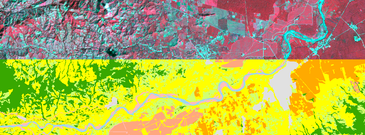
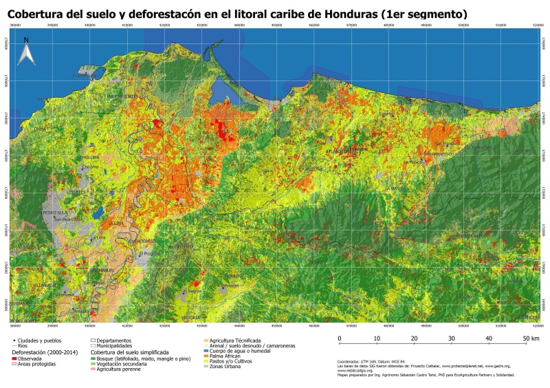
Maps are a great tool for eliciting conversations regarding the value people put on place. In the context of the PASOS initiative, R4Dsct compiled and interpreted spatial data using GIS. This GIS featured different themes: location and extent of protected areas, current land cover and land use, deforestation and topography. As a way of collecting the perspective of the stakeholders that would potentially be involved in the initiative, PASOS collaborators together with R4Dsct conducted numerous interviews and workshops. In many of these activities, group and participatory mapping exercises were performed. This information was also incorporated in the GIS.
Using the GIS, R4Dsct also conducted extensive landscape analysis to identify important areas for natural resource management and conservation and oil palm area expansion trend. As the project moves forward, this GIS is and will continue to support evidence- based strategic planning and project management as well as monitoring and evaluation activities.
Example of a map elaborated by R4Dsct to conduct group and participatory mapping involving stakeholders in the PASOS initiative
Different factors have allowed us at R4Dsct to succesfully provide geospatial services to Solidaridad and EcoAgriculture Partners. One is our proven geospatial expertise in the context of international development projects. Our previous work in Central America was also key. For example, our professional ties with numerous geospatial professionals allowed us to access the most current and accurate spatial data resources for the region. Finally, our expertise conducting field and community work in developing countries was a critical factor.
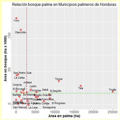
Using spatial analysis, municipalities were ranked according to their area under forest and oil palm plantations.
